Case Study: Rockfall – Manitou Springs

[ED: This brief report from 1995 was written by Jon White, (Senior Engineering Geologist, emeritus). It looks at a specific rockfall situation in the central Front Range town of Manitou Springs. There are hundreds of similar instances like this where gravity rules in mountainous terrain. Geotechnical solutions are of some help in the long-term scale of the hazards, but are extremely expensive to implement. Development pressures that are affecting building in areas threatened by natural disasters—of small and large scale—continue apace in the US West.]

Manitou Springs occupies a narrow valley where Fountain Creek emerges from the foothills northeast of Pikes Peak and west of Colorado Springs. The valley slopes are composed of interbedded resistant sandstone and conglomerates (i.e., gravelly sandstone), and weaker mudstones and shale. The outcropping sandstone is most prevalent on the steeper slopes on the north side of the valley.

During the wet spring of 1995, rockfall and landslide incidents increased throughout Colorado, some resulting in fatalities. In Manitou Springs, a fortunate set of circumstances occurred before the Memorial Day holiday weekend when local residents observed the movements of a large, dangerous block of rock before it actually could fall. The observation set into motion an emergency declaration by the town, resulting in a compulsory evacuation of homes located below the rocky slope, the closing of the road in the area, and an immediate rock stabilization project. During this emergency situation, the Colorado Geological Survey was asked to provide expert assistance to help stabilize the rock. The emergency evacuation decree remained in effect until the rock was stabilized and the area subsequently declared safe.

The ledge of jointed sandstone along with several large displaced blocks is seen at the center of the image. Photo credit Jon White.
more “Case Study: Rockfall – Manitou Springs”

Case Study: Lykins Formation

Small but significant areas of Colorado are underlain by bedrock that is composed of evaporative minerals. These are salts and sulfates that precipitate out of salt-concentrated surface waters. In the geologic past these minerals were deposited in shallow seas within closed or restricted basins where the seawater evaporation rate exceeded the replenishing supply. Current environments that are similar include the Great Salt Lake in Utah and the Dead Sea in the Middle East. These minerals are predominantly anhydrite (CaSO4) and halite (rock salt – NaCl) at depth, and gypsum (CaSO4*H2O) near the surface. Over geologic time, the evaporative minerals filled the sea basins and were subsequently buried beneath younger sediments. Through burial diagenesis, these deposits become evaporite bedrock. After the Rocky Mountains rose, millions of years of subsequent erosion and downcutting of rivers has now exposed some of these evaporite rocks at the surface.

Two characteristics of evaporite bedrock are important. One is that evaporite minerals can flow, like a hot plastic, under certain pressures and temperatures. The second, and most important to land use and development, is that evaporite minerals dissolve in the presence of fresh water. It is this dissolution of the rock that creates caverns, open fissures, streams outletting from bedrock, breccia pipes, subsidence sags and depressions, and sinkholes. These landforms are described collectively as karst morphology. Karst morphology originally referred to limestone areas known for characteristic closed depressions, sinkholes, caverns, and subterranean drainage. Evaporite karst comprises similar morphology where these features develop as a result of dissolution of the evaporite minerals.

more “Case Study: Lykins Formation”

Case Study: The Big One

It has been well over a century since “The Big One”: Colorado’s largest historic earthquake that occurred on 7 November 1882 – Magnitude 6.6.

On Tuesday, 7 November 1882 at about 6:30 p.m. local Denver time, a moderately strong earthquake shook much of Colorado, along with parts of southern Wyoming and northeastern Utah. The following quote from the Rocky Mountain News gives an indication of the shaking in Denver, 60 miles (100 km) from the approximate epicenter.

A general stampede was caused among the employees of The News office, especially in the editorial rooms. The editors and reporters were seated engaged at work when the floors of the editorial rooms began to tremble violently. … for a short time it appeared as if the building was about to tumble in.

— Rocky Mountain News, November 8, 1882

The shaking was so great in Denver that it broke the electrical generators loose from their mounts and knocked out power. The earthquake was apparently felt as far east as Salina, Kansas and perhaps even in Plattsmouth, Nebraska (Rockwood, 1883; Oaks and Kirkham, 1986); and as far west as Salt Lake City.

The earthquake Tuesday evening not only created a sensation but did some damage. It was observed by a few pedestrians who were not particularly interested in the election returns that the electric lights were suddenly extinguished at half past 6. Among the observers was Superintendent Runkle. He went immediately to the electric light building at the foot of Twenty-first street and found that an accident had occurred to the machinery. From the driving pulley of engine there is a connection of shafting five inches in diameter and divided into sections of 12 feet. These sections are connected by large iron bolt screws nearly an inch in diameter. At the instant of the earthquake shock one of those bolts was snapped in twain and the other bent out of shape. The whole machinery was thrown out of gear, and it became necessary to stop the machinery at once. Mr. Runkle is of the opinion that the upheaval which caused the earthquake ran east and west and centered about his establishment and the residency of Mr. Birke Cornforth. It was ascertained yesterday that the shock was so severe in the northern portion of the city that many families ran from their houses.

— The Denver Tribune, November 8, 1882

An aftershock followed on the morning of November 8 and was felt in Denver, Boulder, Greeley, Laramie, and near Meeker. The main event was the largest earthquake to occur in the Colorado region during the historical period (1867-present) and has been the object of considerable study by numerous researchers. Heck (1928) reported the felt area—that is, the total area where credible reports of ‘felt’ earthquake movement and its direct effects were made—as 11,000 mi2 (28,000 km2). Hadsell (1968), as part of the investigation of the earthquakes at the Rocky Mountain Arsenal, conducted the first extensive evaluation of this event. Hadsell concluded the earthquake may have been centered north of Denver and east of Boulder, had maximum intensity of VII, and was ML (local magnitude scale) 5.0 ± 0.6 based on the maximum observed intensity or ML 6.7 ± 0.6 based on its circular felt area of just under 460,000 mi2 (1,200,000 km2).
more “Case Study: The Big One”

Case study: Fluvial Hazard Zone

Front page of the Rocky Mountain News following the catastrophic flood in Big Thompson Canyon in August of 1976. Photo credit: Colorado Geological Survey.

“The Fluvial Hazard Zone (FHZ) is defined as the area a stream has occupied in recent history, may occupy, or may physically influence as it stores and transports water, sediment, and debris.”

House precariously undercut by lateral scour on the Big Thompson River a quarter of a mile below Glen Comfort, Larimer County, August 1976. Photo credit: Ralph Shroba.
Severe road damage from bank erosion along CR-43 (Devils Gulch Road) caused by the extreme flooding event along the northern Front Range of Colorado, September 2013. Photo credit: Jon White for the CGS.

Local, state, and federal agencies often collaborate on projects concerning emergency preparedness and community resilience. In this case, the Colorado Geological Survey assisted the Colorado Water Conservation Board (CWCB), the Colorado Department of Local Affairs (DOLA), and local governments by providing technical expertise for the Colorado Hazard Mapping Program (CHAMP). The CHAMP project facilitates effective long-term flood hazard reduction in Colorado. A crucial part of that process is the development of FHZ mapping protocols and debris flow hazard assessments in combination with traditional floodplain mapping. Community engagement and education on the FHZ protocols is ongoing across the state. more “Case study: Fluvial Hazard Zone”

NASA Earth Observatory

One of my favorite online feeds is from the NASA Earth Observatory along with their Image of the Day. After catching a recent article on the San Luis Valley, I thought that subscribers might be interested in some of the incredible material that NASA offers on a daily basis. This includes front-line data used in climate research.


“The Earth Observatory’s mission is to share with the public the images, stories, and discoveries about the environment, Earth systems, and climate that emerge from NASA research, including its satellite missions, in-the-field research, and models.”


An expansive view of most of Colorado looking from the south-south-west from the International Space Station (ISS). Photo credit: NASA.

The Details

Earth Observatory GIS browserA global map index of thousands of images—one can go direct to Colorado and see more than seventy feature articles covering natural hazards, geology, atmospheric science, and other subjects.

Global MapsA wide range of maps compiled from satellite data.

Feature ArticlesCovering many important topics such as remote sensing, atmosphere, snow & ice, water, and life.

NASA EO blogsIncredibly informative nuggets of research into the natural world, including several topical blogs:

Earth MattersIncludes in-depth reports on everything from Astronaut Photography to Where on Earth?

Notes From the FieldStories about how NASA conducts its scientific work and the technologies that make it all possible.

EO KidsWritten for audiences aged 9 to 14, it has many educational features.

Climate Q&AIncludes in-depth answers to common questions about the global climate.

You may also subscribe to different email newsletters and/or RSS feeds

Case Study: NARD

[ED: I decided to re-work and re-publish some of the public-domain articles that I compiled and wrote for the CGS as they are no longer updating the widely-read >RockTalk<  blog that I established for them back in 2016.

Public interest regarding human-caused water pollution from abandoned mines remains high following the Gold King Mine event in 2015. Complicating the overall water-quality issue is the presence of natural pollution sources that affect the baseline condition of many watersheds across the state. These areas are often accompanied by obvious surface indicators as depicted in the photos.]

Are so-called pristine mountain waters always clean and pure? Can streams unaffected by human activities and livestock influences be unfit for human consumption, or for aquatic life? The existence of natural acid rock drainage (NARD) suggests a “no” to the former, and a “yes” to the latter question.

But what exactly is NARD? 

more “Case Study: NARD”

Case Study: Collapsible Soils

[ED: This report was initially sketched out by Jonathan White, Senior Engineering Geologist, (Emeritus) in 2004. Annual damage estimates due to collapsible soils in the US range between $1-$3 billion. Regional hot-spots in the Southwest include parts of Colorado—the Western Slope (Grand Junction), the Eastern Plains, and because of rapid urbanization and development on marginal soils, Douglas and El Paso Counties. Damage to a single residential structure can exceed $100,000 while repair and mitigation of infrastructure (roads and utilities) can run into the millions of dollars for affected regions or projects.]

At the end of the 19th and beginning of the 20th Century, some of the first settlers of the plateau region of western Colorado along the Colorado River, and the Uncompaghre and North Fork of the Gunnison river basins, looked to fruit crops for their livelihood. The semi-arid but moderate climate was well suited for fruit orchards once irrigation canal systems could be constructed.

But serious problems occurred when certain lands were first broken out for agriculture and wetted by irrigation. They sank, so much in places—up to four feet—that irrigation-canal flow directions were reversed, ponding occurred, and whole orchards, newly planted with fruit trees imported by rail and wagon at considerable expense, were lost. While not understood, fruit growers and agriculturists began to recognize the hazards of sinking ground. Horticulturists with the Colorado Agricultural College and Experimental Station (the predecessor of Colorado State University) made one of the first references to collapsible soil in their 1910 publication, Fruit-Growing in Arid Regions: An Account of Approved Fruit-Growing Practices in the Inter-Mountain Country of Western United States. They warned about sinking ground and in their chapter, Preparation of Land for Planting, made one of the first recommendations for mitigation of the hazard. They stated that when breaking out new land for fruit orchards, the fields should be flood irrigated for a suitable time to induce soil collapse, before final grading of the orchard field, irrigation channels excavation, and planting the fruit tree seedlings.


Piping cave/soil arch in Qamf deposit, Loutzenhizer Arroyo, Delta County, Colorado, April 2007. Photo credit: David Noe for the CGS.

more “Case Study: Collapsible Soils”

Case Study: stormwater

[ED: Although this report centers on a particular region in the Colorado Rockies, the principles apply everywhere—it informs how development affects our most important resource: water.]

Stormwater runoff is excess water associated with a rain or snow storm event that flows over the land surface and is measurable in a downstream river, stream, ditch, gutter, or pipe. From a regulatory perspective, stormwater is managed through some sort of engineered conveyance and is focused on specific pollutants. Hydrologically, stormwater also includes water that is infiltrated into the subsurface and contributes to increased stream discharge.

Check-dams along drainage ditch, Clear Creek County,
Check-dams along drainage ditch, Clear Creek County, Colorado. Photo credit: Colorado Geological Survey.

Urbanization and development causes changes to the natural hydrologic system in a watershed. Alterations in land use and land cover for agriculture, buildings, roads, and other urban infrastructure result in loss of vegetation and topsoil. These changes and the construction of a drainage network alter the hydrology of the impacted area producing radically different flow regimes than the pre-development hydrology. The developed landscape results in a reduction of infiltration and evapotranspiration functions of the soil and vegetation, such that stormwater flows rapidly across the land surface discharging into streams in short, concentrated bursts of high flows. When combined with pollutant sources, increased stormwater runoff leads to water quality and habitat degradation. Stormwater has been identified as a leading source of pollution for all types of waterbodies in the United States.

Traditional stormwater practices were developed with flood control in mind and promote collection and conveyance of precipitation from all storms away from the site to prevent property flooding. This has the unintended consequences of conveying water from small storms out of the watershed, concentrating pollutants, causing stream channel impacts, and depleting groundwater recharge. Local governments with their dual responsibility of land use planning and stormwater management have direct control over stormwater runoff impacts. Research has identified and documented stormwater management technologies and practices that may be implemented locally. These can protect and conserve water resources through the mitigation of detrimental impacts caused by land disturbances and modifications associated with land development.

Get the full (free!) report: OF-09-11 Managing Stormwater to Protect Water Resources in Mountainous Regions of Colorado

Citation

Topper, Ralf E. “OF-09-11 Managing Stormwater to Protect Water Resources in Mountainous Regions of Colorado.” Hydrogeology. Open File Reports. Denver, CO: Colorado Geological Survey, Department of Natural Resources, July 2009. https://coloradogeologicalsurvey.org/publications/managing-stormwater-mountainous-regions/.

Case Study: Clear Creek Canyon rockslide

Rockfalls and rock slides are common along transportation corridors in the Rocky Mountains. Clear Creek Canyon just west of Golden is one of the most active rockfall areas in Colorado. The canyon has been cut into Precambrian schists and gneisses by Clear Creek, one of the primary drainages in the Denver area. Rockfalls occur every year in the canyon in response to freezing and thawing, snowmelt, and intense or prolonged rainfall. Historical rockfalls have ranged in size from small (less than an inch (several cm) in diameter) individual rocks to large boulders up to 10-13 ft (3-4 m) in diameter.

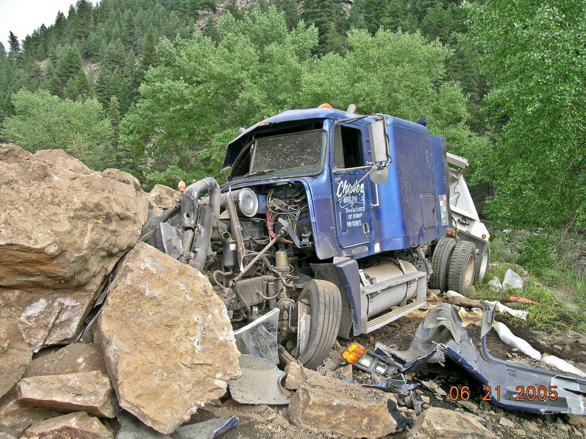
A high-profile rockslide event occurred on June 21, 2005 along U.S. Highway 6 in Clear Creek Canyon, approximately 10 miles (16 km) west of Golden, CO. Around 11 AM, 2,000 cubic yards (1500 m3) of rock slid from a pre-existing road cut on the north side of the road and completely covered the road. Two tractor-trailers were caught in the rockslide and were pushed off the road by the debris. The tractor-trailers were themselves totaled but the drivers sustained only minor injuries.

One of two semi trucks caught in the catastrophic rockfall in Clear Creek Canyon, about 10 miles west of Golden, Colorado. Photo credit: Colorado Geological Survey.

The geology at this location consists of Precambrian metamorphic schist and gneiss, which has been subsequently intruded (cut through by molten rock) with granitic pegmatite dikes. Unfortunately, one of these thin pegmatite dikes that had intruded into the metamorphic rocks was steeply inclined toward the roadway. When the magma intruded the metamorphic rocks and solidified into the granitic pegmatite, the contact between the two rock types became “baked” and the mineralogy and texture of the rock was changed. This “baked” contact zone weathered to produce a transition of clay-rich material. The clayey zone was structurally weak, providing a plane for the rocks above to detach from the underlying rocks and produce this large rock slide.

Jon White, Senior Engineering Geologist, examines the failure zone between the granitic pegmatite and the surrounding metamorphics. Photo credit: Colorado Geological Survey.
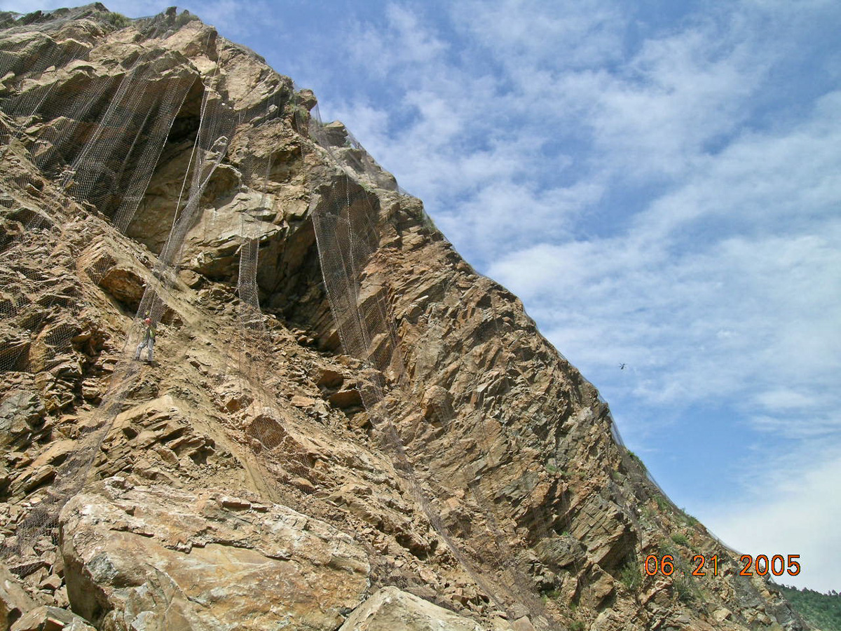
View of the general plane of the slip surface (that is, the surface of the pegmatite intrusion). The wire mesh was in place prior to the June 2005 rock fall to control the inevitable shedding of smaller rocks. Photo credit: Colorado Geological Survey.
View of the slip surface looking north (i.e., the surface of a pegmatite intrusion). The wire mesh was in place prior to the June 2005 rock fall to control the inevitable shedding of smaller rocks. Photo credit: Colorado Geological Survey.
more “Case Study: Clear Creek Canyon rockslide”

Case Study: Roaring Fork sinkhole

[ED: This account from 17 January 2005 was written by Jon White, Senior Engineering Geologist, Emeritus, Colorado Geological Survey. Edited for dated references, it highlights a hazardous geological regime in the central Colorado Rockies around the Roaring Fork River Corridor (across Garfield, Eagle, and Pitkin counties). Over the years, under heavy population pressures, development in Colorado—driven by collusion between profiteering developers and cash-hungry county governments—frequently ignored existing geological conditions. This particular geological situation was not well understood but was generally recognized during the initial wide-scale development in the region. In this case, though, the risk was too small to deter valuable development: and that led to dramatic consequences. Ironbridge, a few years later, saw an protracted legal fight between a number of home-owners and the developers, after the same issue of massive subsidence hit their homes, rendering them uninhabitable.]

Historically, ranching was the dominant land use in the area and [geohazards] caused only relatively minor problems. Recently, rapid development of the valley and its surroundings has fundamentally changed traditional land uses, resulting in higher public exposure to these hazards. To reduce the associated risks, it is necessary to understand these hazards and where they occur. Appropriate levels of investigation, engineering design, and maintenance practices are needed to mitigate these hazards for existing structures and new property and infrastructure development. — from MS-34.

In mid-January 2005, while on the Western Slope, I was informed by a number of people that a sinkhole had opened at an on-going development in the Roaring Fork Valley, somewhere between Glenwood Springs and Carbondale. I made some inquiries with the local geotechnical firms and found that the sinkhole had opened Sunday, January 9, 2005 on the Ironbridge Development off of County Road 109, across the river from Highway 82. I visited the site with the Ironbridge Construction Manager on Thursday, January 13, 2005. There was some damage to golf course structures and loss of equipment. Fortunately there were no injuries or residential loss. This development was previously called Rose Ranch during the Garfield County planning approval process and I reviewed the main submittal and several resubmittals as the county reviewed the application. My main concerns were hydrocompactive soils, debris flow hazards and mitigation, and potential for evaporite karst and formation of sinkholes on the property.

more “Case Study: Roaring Fork sinkhole”

Case Study: Rockfall – St. Francis of Assisi, Castle Rock

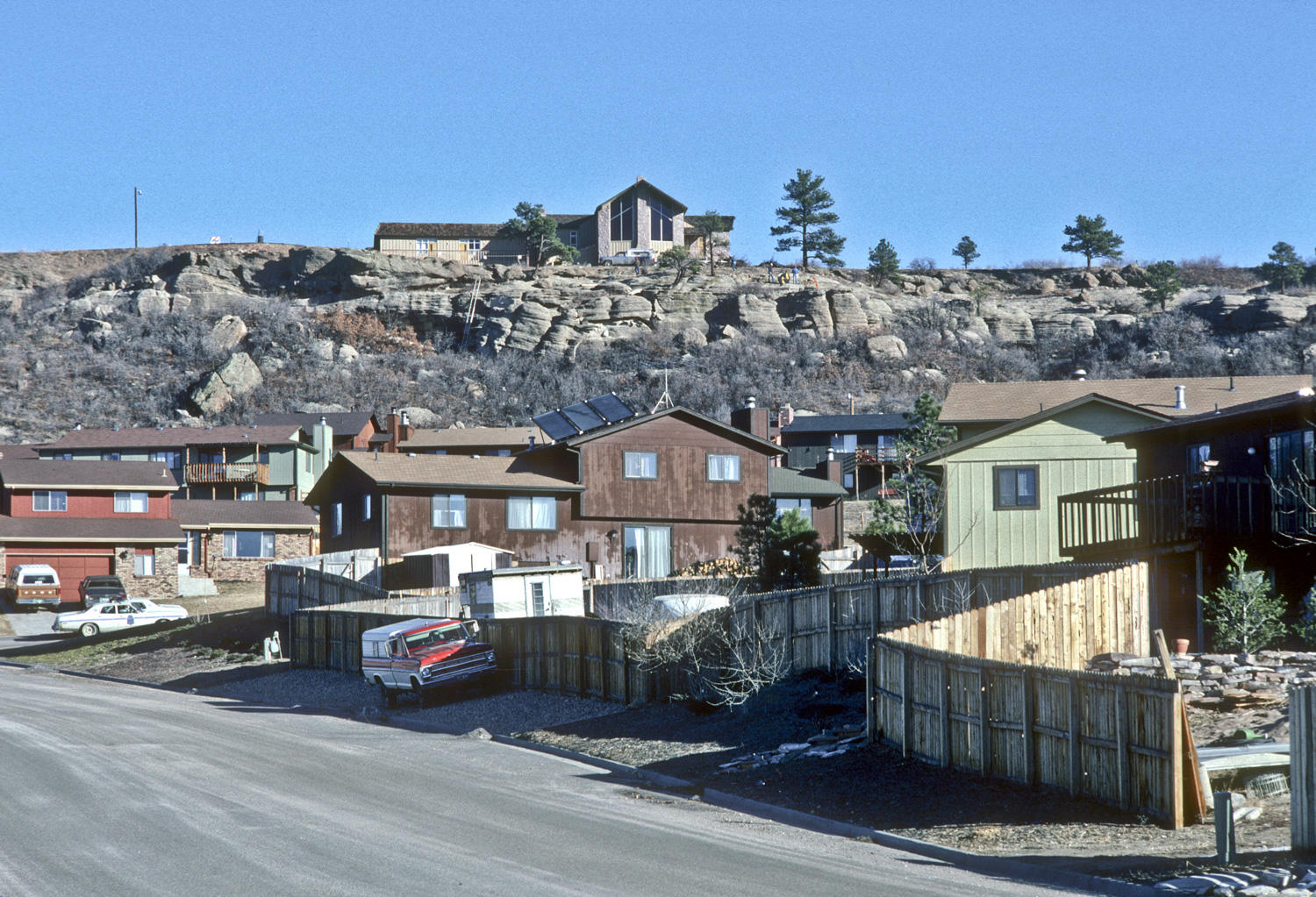
The state geological survey was brought in to examine the site of St. Francis of Assisi Church in Castle Rock, Colorado after a block of sandstone detached from a cliff face on their property in January 1981. The block presented a risk to homes at the base of the slope south of the church property, and was subsequently broken up using passive demolition methods. Other detached blocks continued to present a rockfall hazard to six homes located at the base of the bluff. No consideration was made to address rockfall hazards at the base of the slope when the homes were originally built. Common sense suggests that if there are existing boulders at a construction site, they had to come from somewhere, at some point in time: you can’t fight gravity! There are hundreds of such locations around the state with structures at varying levels of risk.

View from housing development looking up towards the fractured and unstable cliff of Castle Rock Conglomerate, Castle Rock, Colorado, January 1981. Photo credit: Colorado Geological Survey.
View from housing development looking up towards the fractured and unstable cliff of Castle Rock Conglomerate, January 1981. Photo credit: Colorado Geological Survey.
Fresh fracture line, note in the center exposed vegetation roots that were previously wedged between the fallen block and the rest of the Castle Rock Conglomerate cliff, Castle Rock, Colorado, January 1981. Photo credit: Colorado Geological Survey.
Fresh fracture line, note in the center exposed vegetation roots that were previously wedged between the fallen block and the rest of the Castle Rock Conglomerate cliff, January 1981. Photo credit: Colorado Geological Survey.
more “Case Study: Rockfall – St. Francis of Assisi, Castle Rock”