watching Hells Kitchen
the neoscenes/tech-no-mad (b)log ::
traces pathways and actions encountered and undertaken


On July 31, 1976, a powerful thunderstorm over Colorado’s Big Thompson Canyon unleashed a deluge that became one of the state’s most catastrophic natural disasters. Known as the Big Thompson Flood, this event claimed 144 lives, caused significant damage to infrastructure, and left a lasting impact on both the physical and social landscapes. This flood serves as a case study of the interplay between geologic conditions, meteorology, and human activity in a high-risk environment.

The Big Thompson Flood was caused by an intense, stationary thunderstorm that dropped more than 12 inches of rain in just four hours over the steep canyon. The localized nature of the storm, combined with its high rainfall intensity, overwhelmed the Big Thompson River’s drainage system. This type of weather event is not uncommon in Colorado, where summer thunderstorms can deliver large amounts of precipitation over short periods. The semi-arid climate, combined with the region’s high topographic relief, creates conditions that are particularly conducive to flash flooding.
Thunderstorms of this magnitude occur when warm, moist air is forced upward by the mountainous terrain, cooling and condensing into heavy rainfall. In the case of the Big Thompson Flood, the storm’s stationary position ensured that all the precipitation fell within a confined area, greatly intensifying the flood’s impact.
Big Thompson Canyon, located in the Rocky Mountains of northern Colorado, is a steep and narrow valley carved over millions of years by the Big Thompson River. The canyon’s geology is dominated by granitic bedrock interspersed with loose sediments and colluvium, materials that are easily mobilized during heavy rainfall. The steep canyon walls and limited floodplain amplify the destructive potential of flash floods, as water rapidly accumulates and accelerates downhill.

One of the key factors in the severity of the 1976 flood was the canyon’s geomorphology. The steep gradient of the river increased the velocity of the floodwaters, allowing them to carry massive amounts of sediment, debris, and rock. This debris flow not only caused direct damage but also increased the erosive power of the water, undercutting slopes and triggering landslides that further contributed to the destruction.


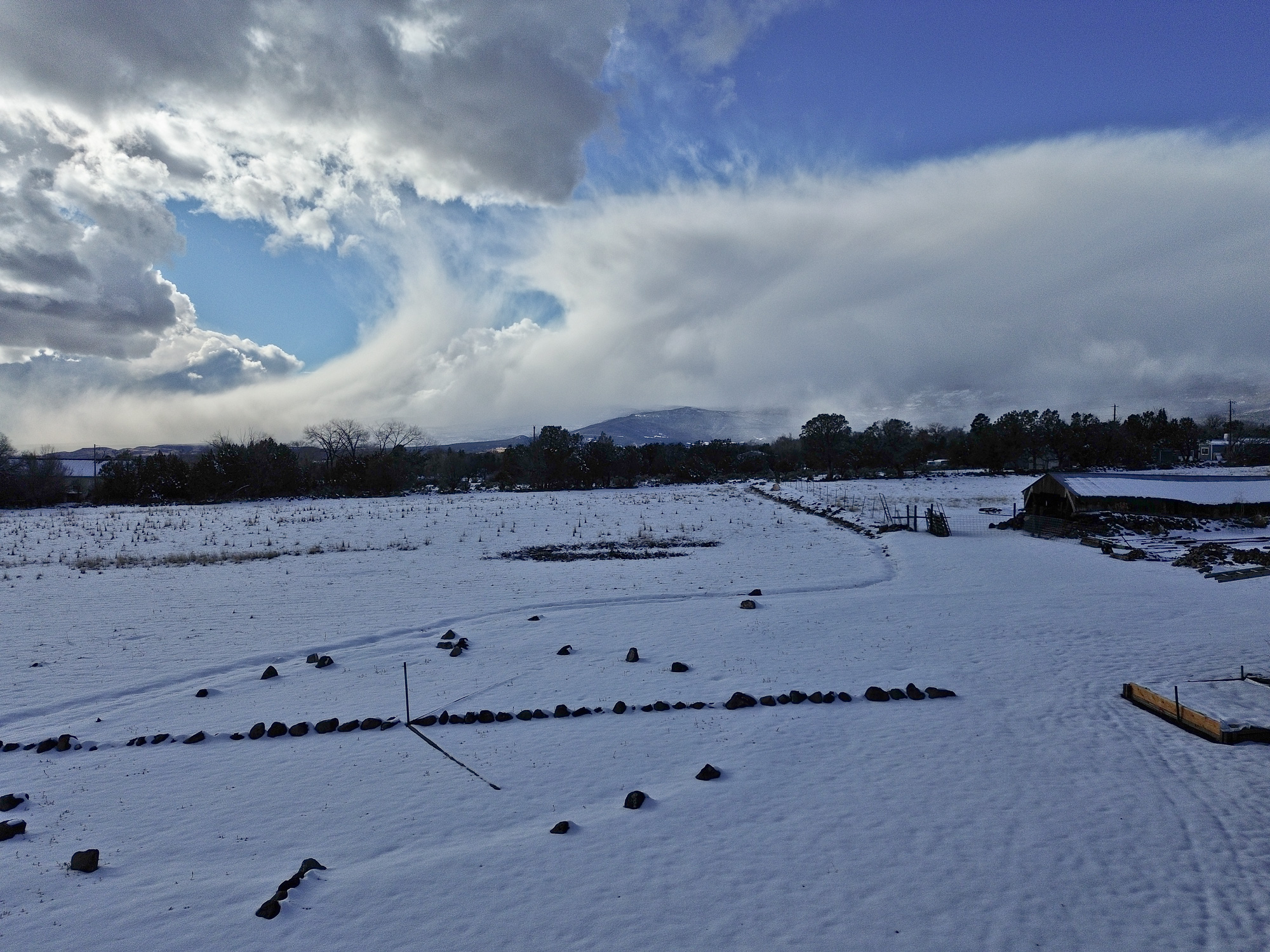
[ED: The far horizon is a portion of Grand Mesa at over 10,000 ft, and the side of the mesa facing the viewer, an area characterized by numerous landslides, is called “Hells Kitchen.” This is the view from my kitchen.]
“The Fluvial Hazard Zone (FHZ) is defined as the area a stream has occupied in recent history, may occupy, or may physically influence as it stores and transports water, sediment, and debris.”

Local, state, and federal agencies often collaborate on projects concerning emergency preparedness and community resilience. In this case, the Colorado Geological Survey assisted the Colorado Water Conservation Board (CWCB), the Colorado Department of Local Affairs (DOLA), and local governments by providing technical expertise for the Colorado Hazard Mapping Program (CHAMP). The CHAMP project facilitates effective long-term flood hazard reduction in Colorado. A crucial part of that process is the development of FHZ mapping protocols and debris flow hazard assessments in combination with traditional floodplain mapping. Community engagement and education on the FHZ protocols is ongoing across the state. more “Case study: Fluvial Hazard Zone”
Ed: For new subscribers, selecting the red dot in the middle of the map will start the audio sample which can then be controlled using the play-bar and volume/mute (speaker) icon.

[ED: If you could see the far horizon, it is comprised of a portion of Grand Mesa at over 10,000 ft, and the side of the mesa facing the viewer, an area characterized by numerous landslides, is called “Hells Kitchen.” This is the view from my kitchen. Another note, my property sits on a large alluvial fan (many tens of sq mi) descending from the Mesa and fueled by Surface Creek. The slope of the fan is minus 10-12 degrees from horizontal, as demonstrated from right to left in the photo.]

[ED: The far horizon is a portion of Grand Mesa at over 10,000 ft, and the side of the mesa facing the viewer, an area characterized by numerous landslides, is called “Hells Kitchen.” This is the view from my kitchen.]


One of my favorite online feeds is from the NASA Earth Observatory along with their Image of the Day. After catching a recent article on the San Luis Valley, I thought that subscribers might be interested in some of the incredible material that NASA offers on a daily basis. This includes front-line data used in climate research.
“The Earth Observatory’s mission is to share with the public the images, stories, and discoveries about the environment, Earth systems, and climate that emerge from NASA research, including its satellite missions, in-the-field research, and models.”

The Details
Earth Observatory GIS browser – A global map index of thousands of images—one can go direct to Colorado and see more than seventy feature articles covering natural hazards, geology, atmospheric science, and other subjects.
Global Maps – A wide range of maps compiled from satellite data.
Feature Articles – Covering many important topics such as remote sensing, atmosphere, snow & ice, water, and life.
NASA EO blogs – Incredibly informative nuggets of research into the natural world, including several topical blogs:
Earth Matters – Includes in-depth reports on everything from Astronaut Photography to Where on Earth?
Notes From the Field – Stories about how NASA conducts its scientific work and the technologies that make it all possible.
EO Kids – Written for audiences aged 9 to 14, it has many educational features.
Climate Q&A – Includes in-depth answers to common questions about the global climate.
You may also subscribe to different email newsletters and/or RSS feeds
[Ed: As the coauthor who developed the structure and presentation of this first-ever fully online publication at the CGS—the Colorado Groundwater Atlas—I wanted to help draw attention to the issue of groundwater generally. This is an edited version of the initial RockTalk blog post when the Atlas was first published in 2020. Written for both the general public (Sections 1-8 and 13) and a technical audience (Sections 9-12), the Atlas is an excellent primer on this critical and rapidly diminishing resource.]
My neighbor, Christie, directed my attention the The Last Word On Nothing (LWON) blog—she writes for it—and I’ve been reading it regularly over the past couple years. That led to my belated discovery of the work of Colorado-based author Craig Childs who also writes for LWON. He’s “an anecdotal science writer, citizen naturalist, an eye in wild places.” I’m currently absorbing and enjoying his first book of essays, “The Secret Knowledge of Water,” published in 2000, a series of intimate takes on this elemental feature of western landscapes. (Well, technically, “Stone Desert Journal,” published in 1999, and republished in 2022, was his first book.)
Water in the US West is a big deal … I should probably assemble a bibliography of essential readings on the topic! Maybe someday. Meanwhile, I’ve got to go water some of the few native trees on my property with captured rainwater that came last night, it’s been a pretty dry year again, so far.
Everyone knows that water, wherever it might be found—at the surface or underground—is essential for life. However, few people are aware that groundwater is everywhere beneath their feet. It fills the pore spaces between grains of soil, sand, and gravel as well as the fractures and voids in hard bedrock (Figure 02-01 – pdf download). It may be just below the surface—accessible by digging with simple garden tools, or it may be hundreds of feet down in hard rock—requiring expensive drilling with specialized equipment.
more “an aside and the Colorado Groundwater Atlas”
[ED: The far horizon is a portion of Grand Mesa at over 10,000 ft, and the side of the mesa facing the viewer, an area characterized by numerous landslides, is called “Hells Kitchen.” This is the view from my kitchen. Another note, my property sits on a large alluvial fan (many tens of sq mi) descending from the Mesa and fueled by Surface Creek. The slope of the fan is minus 10-12 degrees from horizontal, as demonstrated from right to left in the photo.]
It feels like I’m micro-dosing … on everything. Snippets, samples, traces. No mindful full-on inhalation. Only gasps. Inspiration—bringing the spirit into—precluded by lack of creative airs in the surrounds.
The only thing I’m not microdosing on is apricots and cherry plums. Between, jam, purée, preserves, sun-dried, and a pile of pits to be cracked, I’ve not dealt with such volumes of fruit since helping my mother deal with our surfeit of peaches, Back East in rural Maryland. Macro-dosing. Again, after a similar harvest last year.

Many of the volunteer apricot trees on the property were killed in a hard frost in October of 2020. A couple survived, and the single significant one that remained fully intact was in need of heavy pruning after years of neglect. Two winters ago I started taking out the dead wood, lots of it. Pruning, when done properly will usually revivify a failing fruit tree. This one was well worth the effort, and for the past two years, it showed its thanks in the form of a massive bringing-forth of fruit.


As for microdosing. In a world suffused with over-amplified signals, microdosing has the potential to remind our presence of at least the possibility of psycho-spiritual transcendence. A bowl of vanilla ice cream with some apricot purée anyone? Or just one of those glorious apricots?
Aside: George recommends Bird by Bird.


A new word crosses the textual radar: virga. Seen often in Western skies, especially immediately prior to Monsoon season, and during transitional seasons. Puzzled that I don’t recall knowing it before. Maybe I just don’t remember.
Best described as wispy filaments of rain, thin curtains, falling beneath storm clouds that haven’t the energy to transition into full-on thunderheads: the falling precipitation evaporates before reaching the ground. Extremely frustrating to the parched throats waiting for any water to fall from heaven in these desert regions.
In the metaphoric: life-blessing from Heaven, reaching the soul on occasion. sensed, though far away. ethereal. falling to quench the soul. gone.

Wee, sleekit, cowran, tim’rous beastie,
O, what a panic’s in thy breastie!
Thou need na start awa sae hasty,
Wi’ bickering brattle!
I wad be laith to rin an’ chase thee,
Wi’ murd’ring pattle! more “Burns’ homo rodentans”

Months pass, few thoughts arise worthy for commitment to this php database: The gritty scrape of hoe along the bottom of a wheelbarrow, mixing concrete: water, sand, and Portland come together in an exothermic reaction, to make a conglomerate, stronger than natural stone. Not worthy, not beautiful, only indicating the changes that increases the entropy of the universe. Sorry about that. (Oh that’s right, I’m not supposed to second-guess myself – practice preaching!) Sanding wood to a higher state of finish. Painting: watching closely as moving liquids coalesce in thin films that alter reality: “two coats of paint makes what is what it ain’t”. Dry wall taping. Hiding defects in visually smooth surfaces.
What is either the last of the monsoons or the first of the El Niño begins to drive through, smattering rain now, more hoped for later. Bands of moisture from the south seem to avoid this region. Drought continues.
Concluded how low-tech my $1500 D200 Nikon body — nine years old and worth $150 now — is. The optics are shit, always were. Nikon abdicated their position as a decent SLR system. I should switch back to some of the vintage all-manual Nikon lenses that I’ve got to see if that helps. But a decade of photography looks like it’s been done on a Diana! faugh. This conclusion has been roiling internally for at least five, six years. Came to surface when making a series of documentary photos of plants on the property, they are terrible! I could do better making pencil sketches with my left hand! But without capital, no change is possible. I do have a slew of technical drawing pencils, including one that accompanied the last few semesters of study at the School of Mines, so long ago. So many small and larger evidences of the past accompany me to this point, perhaps into the future, perhaps not. The burden of materiality is not to be lost through any transformative Lightness of Being in the moment. The ground and the plants rising up from the ground become the chief object of my attention, gathering native seeds for re-seeding, sky largely forgotten as obscured by ponderosas.
