the Solstice, in Echo Park. what more to ask?
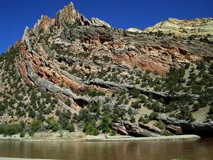
walking upstream in Pool Creek Canyon above the abandoned ranch. cross one branch of that major fault, and there the creek is, totally spring fed, gushing from a sand bank in the center line of that huge fault. continue up the canyon in the dry wash. find a cave with a crude lean-to fashioned in it. hung with clothes, boots, and other items. old, very old. at least 50 years, perhaps 75. on the wall are a couple rock paintings. the clothes are working ranch clothes, the rock paintings appear to be authentic. I do not disturb anything, but am very conscious that my boots are making footprints in the sand floor. continuing up the arroyo, the canyon is defined by subtle and massive structural essences of the rock. on the uplifted side of the fault, the underlying limestone shows in the wash. the down-thrown side is at least 1000 feet lower. dramatic geology, good location for field mapping exercises.
sense a mountain lion at one point, the sage is often taller than my head, so, walking through deep brush, scrambling over rockfalls, peering into the numerous caves formed in the eroded sandstone. shooting many images. this is one of the best walks taken in the area. with plenty of cool places to stop, even in the vibrating mid-day zenith of the Solstice sun — overhangs, caves, some Douglas Fir trees, large old junipers, and areas of over-hung canyon wall, rising a few hundred feet above. the absolute depth is about 800-1000 feet, perhaps a bit more. I do not go as far as I can, but stop for 30 minutes to remove fox-tail burrs from pants, socks, and boot liners, where they are beginning to drill into my skin.
Loki does not accompany me.
we later swim/wade upstream to the Green/Yampa confluence and explore. the Yampa seems a few weeks yet too strong to cross. the current is strong even in the hip-deep areas, making a perfect speed for swimming a hard workout in place. the flow of the Yampa is around 2000 (cubic feet per second, cfs), it was twice that at the beginning of the month (see the USGS water data site). in May it can reach up to 20000 cfs on rare occasions — with good snowpack and rapidly increasing spring temps. the Green is half that, and does not vary from around 900 cfs because of the Flaming Gorge Dam. there are a pair of beavers who have found a sheltered cove to hang out in, noshing on aspens up to five inches in diameter which they have cut down and dragged to the river, leaving strange markings in the sand whilst doing so.
the previous day, coming down from the Uinta Mountains, we pass the monstrous phosphate mine which has modified a significant chunk of the south side of the Uintas. I continue work on the Domination of Landscape series to be uploaded later. everywhere in the west is plenty of material for this project. unfortunately.